
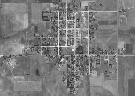
MOVING UPHILL - This aerial photo of New Richland, taken in the 1930s, shows development in the city moving to the west and north, while avoiding flood-prone areas to the south and east. Highway 13 did not yet exist when this photo was taken.
Long-term analysis, a path toward flood relief for New Richland
Earliest phases of water reroute planning laid important foundations
Earliest phases of water reroute planning laid important foundations
Thu, 10/22/2026 - 8:30am
Waseca County Land and Water Resources director Chris Howard says it's understandable that people feel there has been little or no progress in reducing the amount of water which flows through New Richland during significant rain events. He shares, though, that through continued collaboration with the City of New Richland, Although there has been movement forward, it has been behind the scenes, and has been targeted mostly to understanding what the specific sources of the water are, how much they contribute, and how the effects can be minimized. The flood mitigation study was ordered by the City of New Richland in 2023 with Waseca County providing additional funding and technical resources in meeting state laws (Chapter 103E) pertaining to public drainage systems affecting the city.
Working for both the city and the county, Houston Engineering of Maple Grove began a water flow study in 2023, and has already devised computer models which can indicate what properties will be affected depending on the amount and location of rainfall the area receives. The cost of various solutions has been examined, including property buyouts, flood walls, reroutes, improvements and increasing existing culvert capacities.
In the end, engineers suggested the most holistic solution calls for $10 million or more worth of excavation to create 11,000 feet of channel and integrated water storage to catch water which would otherwise flow into town from the east, south and southwest and carry it to the west, delivering it to Boot Creek at a downstream location.
The plan is to design the channel to carry the nearly 200,000 gallons per acre of water which result from a 100-year rainfall–one like the city experienced on Sept. 19 with 7 inches of rain within a 24-hour period. The flooding event in 2016, Howard shared, was certainly catastrophic, but because rainfall came in separate events across two separate days, it did not meet the criteria for being a 100-year-event.
Preliminary plans for the channel indicate it would require easements on about 50 acres of property and might need to be up to 35 feet deep in places. How long it will take to secure funding and satisfy statutory requirements is unknown, Howard says, but once all elements are in place, it will take about 1.5 years to construct the channel.
Howard has been preparing funding requests for the project for months already, and meeting with area landowners to see how open they are to allowing the channel to pass through their property.
In preparing applications, he has encountered numerous factors which must be balanced alongside each other. Agencies which might supply funding have specifications and expectations for projects they support. At the same time, Minnesota statute regarding drainage and drainage systems has more than 100 sections which state fairly succinctly all the processes which must be followed to create, maintain, expand or improve, and perhaps eventually abandon a manmade drainage system. One needn’t read very far to figure out ditches affect many people, and many steps are needed to work toward treating all of them as fairly as possible. Perhaps because of that highly political nature, drainage laws are very specific on many points.
Public interests such as water quality, public safety and environmental considerations must be balanced with fair treatment of landowners and complying with state law. All of those become factors in preparing requests for funding, and in some cases there are conflicts between the statutory requirements of various agencies.
Howard concedes that the publicity surrounding the recent tragedy will likely increase how receptive agencies are to helping, but they will still require state statute to met. We cannot simply transfer our problems to another town or community downstream.
Another way the application’s impact may be strengthened is that survey measurements made on Sept. 19 indicated water levels within one or two tenths of an inch to those in forecasts created using Houston Engineering’s computer models, verifying their accuracy.