
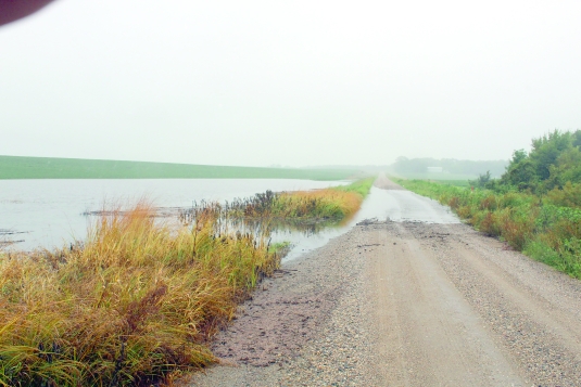
OVERFLOW - Heavy rains have caused the overflooding of roadways in Waseca County at least twice this summer. Here, rising waters from the nearby LeSueur River caused water to cross a Wilton Township road on July 23. Star Eagle photo by Deb Bently
Widespread affects of record-setting rainfall
Tue, 09/02/2025 - 12:30am
An August 17 and 18 rainstorm dropped 9.48 inches of rain at the 111-year weather station at the University of Minnesota’s Southern Outreach and Research Center (SROC) located in Waseca. SROC staff and other recordkeepers, who provided unofficial rainfall amounts for the same event, recorded rainfall around the county as high as 11 inches.
Information compiled by SROC staff members Stephanie Schnoor and Kyle Holling reports the Aug. 17 and 18 event contributed to numerous records, including the wettest June to August summer in the station’s history, the third-wettest August and the eighth-wettest growing season since statistics began being collected in 1914. All this even though the summary was released on Aug. 20, with 11 days of the month remaining at the time.
The 9.48 inch rainfall is the second-largest 24-hour total the station has ever reported, falling in line behind 10.16 inches which dropped there on Sept. 21 and 22 of 2016.
Waseca Soil and Water Conservation District Manager Mark Schaetzke commented, “We continue to see higher intensity rainfall events. Amounts have been variable where one farm gets a very normal one-inch rain and another area 20 miles away gets a four-inch gullywasher.” Schaetzke pointed out the global information system (GIS) places southern Minnesota in a zone where longstanding classification claims a single event totalling as much as four to five inches of rain should happen only once in a ten-year period.
“It sure seems like we are getting more than that,” he observed. “And many times that four-inch rain is coming in only three to four hours rather than taking all day.”
Significant erosion and flooding now seem to happen in vulnerable areas every year, he said. “It takes only one high-intensity storm to cause this damage.”
Waseca County Highway Engineer Jim Kollar recalls at least two rainfall events this summer which led to water “overtopping” roadways in the county, and more where water filled roadside ditches to the level of the road. “When a flood happens,” he mentioned, “we abandon our normal operations and respond to the flood: Closing roads, monitoring conditions, performing repairs as needed.
“We also inspect our bridge crossings and major culverts for tree debris.”
Disruption continues after the water recedes, he continued, as staff members look for erosion and ensure safe driving conditions by carrying out any needed repairs.
“Wet summers certainly affect construction,” Kollar finished. “Both major events this year flooded out box culvert [replacement] projects that were in progress.” Once flooding occurs, he said, workers have no choice but to wait until construction locations become suitable for any repairs before continuing construction.
SROC scientist Jeffrey Vetsch observes the timing of a large rainfall event has significant influence regarding how much damage it causes to farm yields. One source of yield loss can be a delayed planting season, when early rains keep farmers out of their fields.
Vetsch says heavy rains early in the growth cycle can be the most harmful. Once seeds are in the ground, germination and early growth are impeded in numerous ways. The presence of standing water, of course, creates bare patches in the field. Less visible damage is occurring in all sections of the planting, however, because oxygen is pushed out of water-saturated soil, ground temperatures are kept cooler, and nutrient inputs may be leached away.
Later in the season, well-developed plants “transpire” significant amounts of water as they grow, Vetsch says. Because of this natural cycle in which plants draw up groundwater, circulate it internally and then allow it to evaporate off their surfaces, heavy rainfall is less detrimental.
Noting that the 9.5 inch rainfall in mid-August was record-setting, Vetsch commented, “This amount is so rare that its affects on crops are difficult to measure or predict.”
When water stands in an area of a field for more than three days, plants are likely to die due to lack of oxygen, he mentioned. “Even if plants don’t die, they are still negatively impacted in other ways, like greater disease incidence and nutrient loss.”
Vetsch also pointed out that drainage is vital in southern Minnesota soils, and the region generally has a well-developed system of tiles and open waterways in place. It is, however, “inadequate for these really large events like Aug. 17 to 18.
“It wouldn’t be practical logistically or financially to design them for these events.”
He notes that 2024 grain yields were decreased by 10 to 30 percent below expected in parts of South Dakota, southern Minnesota and Iowa, largely because of heavy rainfall.
For 2025: “Areas that received excessive rainfall in late May and June will be affected more than late July and August of 2025. Flooded and drowned-out areas will yield zero or very low, but the rest of the fields look very good.”
The SROC Aug. 20 report mentioned “growing degree units” (GDUs) were 30 percent above normal for the week of Aug. 14 to 20, and the growing season overall is nine percent above.
SROC weather data can be viewed at https://sroc.cfans.umn.edu.