
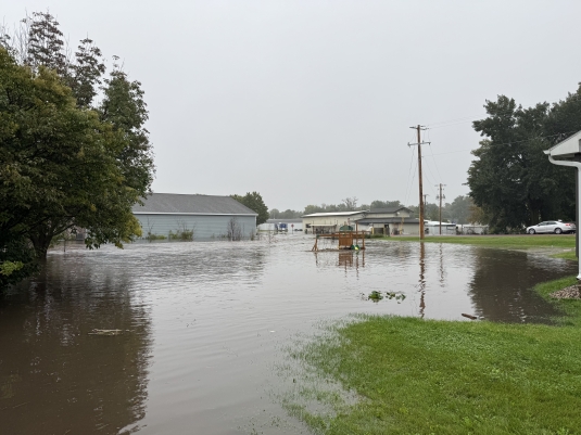
FUTURE FLOODING - Between 80 and 100 acres of New Richland were under water at the peak of the Sept. 19 flood. Analysis and planning toward alleviating future flooding has been on-going for about 5 years, beginning with a study in 2022. Star Eagle photo by Deb Bently
Historic factors influenced city development, water flow
Thu, 10/22/2026 - 8:15am
Waseca Land and Water Resources director Chris Howard has devoted many hours of attention to determining and analyzing water flow through New Richland, beginning in 2023 soon after he was first hired by the county.
He does not disagree with a statement made by one area resident that, when it comes to drainage in the southern part of the county, New Richland takes on the role of being a holding pond–that is, water pools there in the town’s lower elevations until drainage downstream allows it to flow away.
He shares his observation that locations for cities in the early decades of the county were based on two factors: access to the railroad as a vital provider of transportation, and access to water.
He has found vintage aerial photos which show that, in the 1930s, development in the town had stayed on high ground, moving north and west from the downtown district and avoiding the low lying land to the east and south which had a tendency to flood.
In the 1970s, the natural water channel through town was made deeper and wider by the construction of two drainage systems, Joint County Ditch 6 and County Ditch 47, and in some cases the capacities of existing culverts–the “bottlenecks” of a drainage system–were increased.
The resulting improved drainage apparently emboldened people to acquire lower lying land and build on it.
“There have always been issues with drainage in New Richland during large water events,” Howard summarized. “Now, with weather systems that deliver a lot of rain at once, that flooding is more evident.” He also points out the public drainage systems constructed in the 1970s were designed for 2-, 5-, and 10-year, rather than 100-year events.
Using the county’s Beacon mapping system, Howard demonstrates that elevations in New Richland range from 1,172 feet above sea level along the waterway and in the baseball field, and are as high as 1,186 in the area of downtown. He estimates that between 80 and 100 acres of New Richland were underwater on Sept. 19, with depths of six feet at the lowest elevations, with 3 to 4 feet being much more common.
While people may feel a tendency to blame drainage ditches for delivering water into town, Howard points out that water will always move from higher elevations to lower ones. The natural waterway through town would automatically be a catching point for water due to its lower elevation. Since one inch of water on an acre of land equals 27,000 gallons of water, the 7-inch rainfall delivered 189,000 gallons of water to the 5,000 acre contributing watershed through New Richland.
Howard closed with an observation that the historic multi-decade problem plaguing the residents of New Richland is being addressed by a reputable, nationwide engineering firm which has the best interests of the City of New Richland and Waseca County in mind. “The problem cannot be addressed soon enough,” he said, “but progress is forthcoming.”